| |
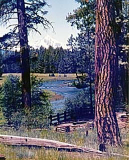
There are few places where you can witness the primeval forces that shaped our land, especially back-dropped by the highest concentration of snow-capped volcanoes in the lower 48 states. The 82-mile loop McKenzie Pass-Santiam Pass National Scenic Byway, in Oregon’s Cascade Mountain Range, traverses some of the most recent volcanic lava flows in the state while tracing the path of meandering rivers, traipsing through old-growth forest, and summiting high mountain passes.
| |
|
|
| |
|
|
| |
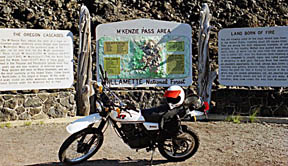
Oregon Cascades: Signs help explain what you see as you drive the Byway |
|
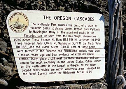
The Cascade mountains began erupting about 35 million years ago, and over the next 15 million years they produced enough ash to lay a 1,000- foot thick blanket over the Northwest. Most of the mountain range developed from lava and cinder spewed from shield volcanoes - low-profile, cone-shaped furies. This was followed by the Columbia River Basalts, flow upon flow of lava gushing from countless vents, until only the highest peaks stood above the huge, flat, lava-iced plains. Many of these peaks still bear glaciers, among the most southerly in North America, which eroded them into their present shapes.
| |
|
|
|
|
| |
|
|
|
|
| |
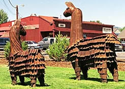
Raising llamas is popular in the Sisters area |
|
Even the town of Sisters has its own llama “herd” |
|
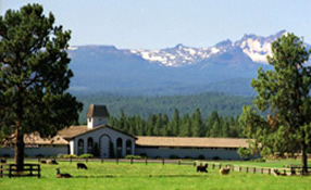
The East Portal of the Byway begins in Sisters with its distinctive Old-West atmosphere, situated at the junction of Highways 20, 126 and 242. Restaurants, galleries and shops of all sorts intersperse along its main street, and llama ranches dot the roads in and out of town. North of town, the road skirts the base of Black Butte, a 6,415-foot cone of black ash and cinder.
| |
The placid birthplace of the Metolius River is in stark contrast to the torrent into which it evolves |
 |
|
A five-mile detour along Highway 14 leads to Camp Sherman and Wizard Falls Fish Hatchery, where several varieties of trout and Atlantic salmon are raised in a park-like setting. The crystal clear water of the Metolius River springs forth in a meadow at the base of Black Butte, its source still a mystery as it forms one of the largest spring-fed rivers in the nation and one of the finest rainbow trout streams in the West.
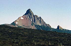
A few miles north of 4,817-foot Santiam Pass, where the Pacific Crest Trail crosses the highway, Three Fingered Jack rises 7,841 feet into the sky. From the turnoff to Hoodoo Ski Bowl, a four-mile jaunt south takes you to Big Lake, whose clear blue water appears to lap at the foot of Mt. Washington. |
|
| |
|
|
|
|
|
| |
One mile east of the Santiam Junction are parking lots for Little Nash Crater and Sawyers Ice Cave. An intriguing lava tube begins near here, with two more sections a quarter-mile beyond. On the left you'll see 4,770-foot Nash Crater, and beyond it, 5,460-foot Sand Mountain - more evidence of the area’s tumultuous past. |
|
 |
|
|
| |
|
|
Mt. Washington is surrounded by 52,516 acres of designated wilderness |
|
|
| |
|
|
|
|
| |
 |
|
South on Highway 126, deep fields of lava form both sides of the road. Runoff from winter snow feeds numerous lakes and waterfalls along this route. Clear Lake is about three miles and Ice Cap Creek five miles south of the turnoff onto Highway 126. Millennia ago the McKenzie lava flow formed a dam across the old Santiam Valley, leaving a 2,000-foot depression. Springs gushing forth in this hollow give birth to Clear Lake - so clear, you can see 3,000-year-old tree trunks in its 40-foot depths. |
|
| |
Central Cascades: Dramatic examples of the area’s volcanic past line the horizon |
|
|
|
| |
|
|
|
|
| |
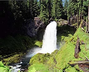
When lava from Belknap Crater blocked the ancient riverbed of the McKenzie, it created a trio of spectacular waterfalls. A short walk from the parking lot at Sahalie Falls to observation points overlooks a jewel whose name means “heaven” in Chinook jargon. Just beyond Sahalie you will find Koosah Falls (Chinook for "Sky"), plunging 82 feet over a basalt cliff. Tamolitch Falls, about two miles south of Ice Cap Creek, is accessible only by trail. Nearby Beaver Marsh is a bird watching hot spot.
Belknap Hot Springs is a peaceful resort on the McKenzie River, a Wild and Scenic River known for native rainbow trout. The large outdoor swimming pool is fed straight from the hot springs that percolate through this volcanic landscape. |
|
 |
|
| |
|
|
Sahalie Falls plummets 68 feet in the midst of a sylvan haven |
|
| |
|
|
|
|
| |
 |
|
 |
|
| |
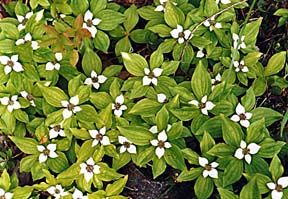
Wildflowers carpet the forest floor |
|
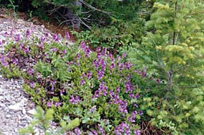
Lupine colors the hillsides |
|
The Byway’s West Portal begins at the junction of Highways 242 and 126, about five miles east of McKenzie Bridge. The narrow corridor through thick forests of fir, cedar and hemlock winds through the forest primeval.
Turning east onto Highway 242 brings you to the last and most awesome leg of our loop, the McKenzie Pass. Called the narrowest, most crooked, loneliest and most spectacular road across the Cascades, it is generally closed due to snow from mid-November to mid-June.
| |
|
|
|
|
| |
Just past the junction is the Mt. Washington Wilderness Area, with more volcanic buttes and pristine lakes than can be imagined. About 8.5 miles along this route is the turnoff for the trail into the Three Sisters Wilderness, Proxy Falls and Lower Proxy Falls. A one-half mile trail leads to these well-loved, much-photographed examples of the beauty nature can create from water, trees, fern and moss-draped rocks. |
|
|
|
| |
|
|
Buried by snow in the winter, the McKenzie Pass holds a bounty of recreational opportunities |
|
| |
|
|
|
|
| |
|
|
The lava dam creating Proxy and Lower Proxy Falls came from Collier Cone on the side of the North Sister. There is no visible outlet for the water from the upper Falls; it is assumed to drain deep into the porous ground, reappearing as cold, sparkling wetness somewhere below. Lower Proxy Falls races down a rock wall to the canyon floor, reforms into a stream, and begins its trek to the Pacific Ocean.
|
|
| |
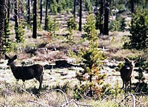
The many inhabitants of this area include deer, elk, bear, large cats, bald eagles and the spotted owl |
|
|
|
| |
In the 1800s, Alder Springs Campground was a corral for livestock being driven over the Cascades. To the south is a dazzling view of the Obsidian Cliffs, followed by Deadhorse Grade which climbs almost 1,200 feet in under a half-mile. At the top is Frog Camp campground, a popular take-off point for Three Sisters Wilderness trips, and the turnoff to Scott Lake.
The stark lava fields around Belknap Crater Viewpoint are superb examples of shield volcanoes. To the north, the 1,700-foot thick complex extends five miles in diameter and includes 8,877-foot Big Belknap Crater and Little Belknap Crater's 6,305-foot cinder cone. The latter was the origin of the immense lava fields in the foreground; its eruption about 3,000 years ago discharged molten rock 12 miles westward. |
|
| |
|
|
| |
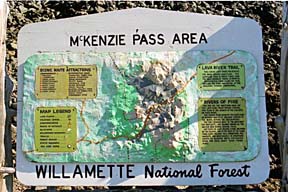
Signs help interpret the unusual landscape along the Byway |
|
At McKenzie Pass, the highest point on the Byway at 5,325 feet, the Pacific Crest Trail again crosses asphalt. From this point the highway winds its way across fields of extensive, ancient lava flows, down the east slopes of the Cascades through mixed conifer woodland and eventually into Ponderosa Pine forests.
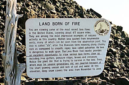
These lava fields and cinder cones, once a training site for moon-bound astronauts, are from the most recent lava flow in the continental U.S., about 1,500 to 30,000 years ago, and are among the most impressive examples of volcanic activity in the United States.
| |
|
|
|
|
| |
 |
|
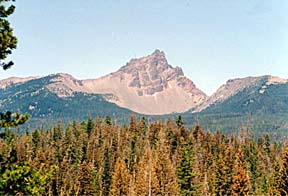
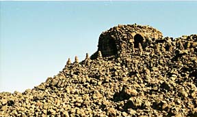
The Dee Wright Observatory was built of lava rock atop the flow from Belknap Crater. From the top of the Observatory you can identify the peaks circling this startling land. To the north are Mt. Hood (11,245 feet and 79 miles away), Mt. Jefferson (10,497 feet and 28 miles) and Mt. Washington (7,794 feet). To the southeast sit North Sister (10,085 feet), Middle Sister (10,047 feet) and The Husband (7,526 feet) - the latter four all less than ten miles "distant". |
|
| |
The Dee Wright Observatory was constructed by the Civilian Conservation Corps in the 1930s |
|
|
|
| |
|
|
|
|
| |
From here, the barrier-free access Lava River Interpretive Trail provides an up-close view of various lava forms including lava gutters, pressure ridges, levees and crevasses. The half-mile trail starts and ends near the Observatory, and sections of it were part of the McKenzie Salt Springs and Deschutes Wagon Road, built in the late 1860s. The Windy Point viewpoint, at 4,909 feet elevation, overlooks a 65-square-mile flow situated at the edge of the Mt. Washington Wilderness. |
|
 |
|
| |
|
|
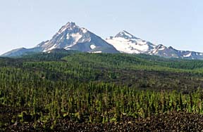
The North and Middle Sisters are just two beauties in a string of volcanic mountains |
|
| |
|
|
|
|
| |
 |
|
Numerous campgrounds offering an assortment of amenities and recreational possibilities are situated along the loop. RV sites are also available at Black Butte Ranch, Blue Lake Resort and Belknap Hot Springs. |
|
| |
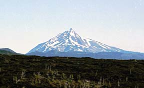
Designated wilderness area around Mt. Jefferson covers over 100,000 acres |
|
|
|
| |
|
|
|
|
| |
 |
|
|
|
| |
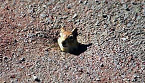
Use caution pulling into asphalt pullouts… |
|
What appears to be just a hole in the asphalt may be the doorway to some local’s home |
|
Whether you embark upon the Byway from the East Portal or West, in a clock-wise or counter-clockwise route, you will be overwhelmed by the eons of geological history and contrasting beauty of this unique landscape. |
|