High on Adventure
JANUARY/FEBRUARY 2022, OUR 26TH YEAR
ON THE ROAD AGAIN |
||||||||||||||||||||||||||||||||||||||||||||||||||||||||||||||||||||||||||||||||||||||||||||||||||||||||||||||||||||||||||||||||||||||||||||||||||||||||||||||||||||||||||||||||||||||||||||||||||||||||||||||||||||||||||||
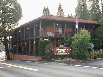
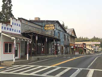
As the pandemic continued to complicate travel adventures, my wife and I chose to drive instead of fly across the country for a class she was to take on the opposite coast. While the rules for access indoors at restaurants, hotels, bed ’n breakfasts and tourist attractions varied by locale and Covid numbers, everywhere we went there were places and things to see outdoors. Here’s a look at what we saw heading west-to-east from California to Maryland - then, in the next edition of High on Adventure, we’ll share the sights from the east-to-west portion of the trip. We started with a short drive of a mere 160 miles across part of Northern California from San Francisco to the former gold rush town of Groveland which is close to the entrance to Yosemite Park. We had booked ourselves into the Groveland Hotel so we could get an early start the next day for a daylight drive through Yosemite Park and its Hetch Hetchy Valley. Groveland, it turns out, is on a creek that was a major gold strike during the gold rush of 1849. The hotel dates to that year and the Iron Door Saloon down the street has been in continuous business as a purveyor of strong spirits since 1852.
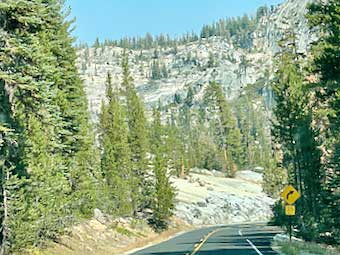
On our early start the next morning we were instantly rewarded with marvelous vistas through the windshield and even greater ones when when we stepped out of the car for a stretch.
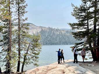
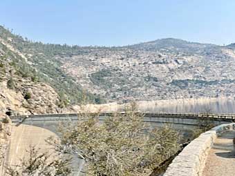
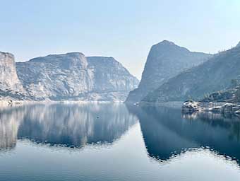
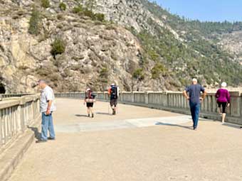
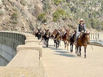
Most of the visitors to Yosemite Park go into Yosemite Valley. However, due to the fires ravaging California this fall, that valley was reserved for only those staying overnight. The northern part of the park, however, features incredible views of the glacier-carved Hetch Hetchy valley - or more precisely, the Hetch Hetchy lake. The valley has been inundated behind a dam built in the nineteen-teens to capture water from the Hetch Hetchy River. The resulting reservoir serves as the source of water for the city of San Francisco. We drove up to the dam and took in the view over the water - a spectacular sight most Yosemite Park visitors miss.
We were among the few humans strolling across the dam, but had to make way for the animal traffic, as horse-mounted rangers brought a mule train by.
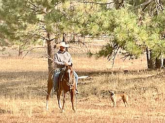
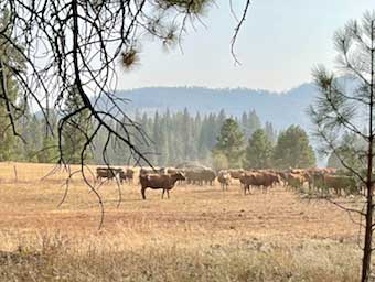
Horse-mounted humans were in evidence on the ground as well, as we spotted a cowboy watching o’re his herd by day.
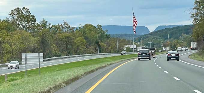
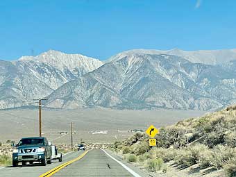
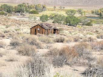
Moving on to Nevada, the high desert opened up under us with little evidence of occupation.
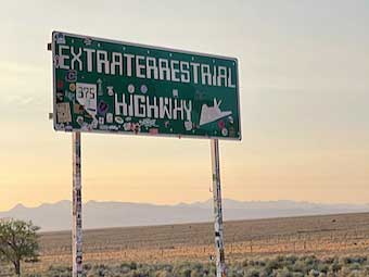
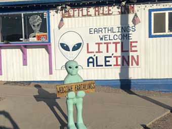
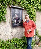
Soon we approached Highway 375 - better known as the “Extraterrestrial Highway” as it wound past the famous (or infamous) “Area 51” where UFO and Alien seekers harbor suspicions of coverups. We were welcomed by a little green man at the Little Álé Inn where we enjoyed a distinctly terrestrial café latte.
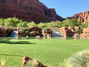
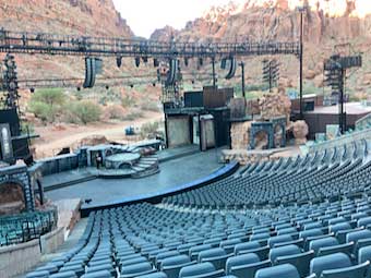
The south/west corner of Utah welcomed us with the lush and lovely entrance to the Tuacahn Center for the Arts. The Center boasts a marvelous 2,174-seat amphitheater at which are mounted Broadway-style musicals in front of the even more dramatic view of the 1,500-foot high red-rock cliffs at the mouth of Padre Canyon. On the evening of our visit the show we saw was a musical of The Count of Monte Cristo with music by Frank Wildhorn, one of only two American composers to have three musicals playing simultaneously on Broadway this century. The book and lyrics were written by Jack Murphy who handled those same roles for Wildhorn for musicals playing on Broadway, in Europe and Asia. It was, to say the least, a kick!
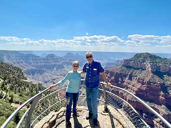
After crossing the border into Arizona, we took a most rewarding detour to the North Rim Overlook of the Grand Canyon National Park. Much less frequently visited than the southern side of this phenomenon of nature, the North Rim Overlook offers views like no others - as you can see from this shot of us taken by a friendly fellow tourist.
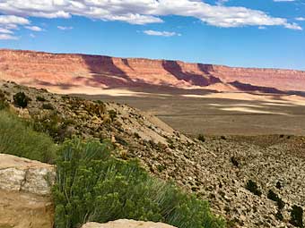
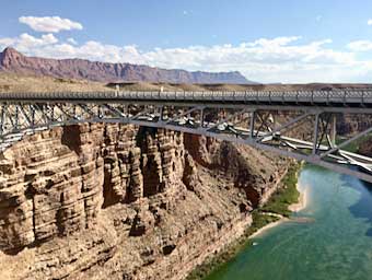
As we proceeded deeper into Arizona, we witnessed one more spectacle to boggle our minds - the well-named Vermilion Cliffs (named, by the way, by John Wesley Powell during his 1869 expedition down the Colorado River). We could see that the south-facing cliffs at the edge of the Paria Plateau dominated the vista as we approached the Colorado River and crossed using the new Navajo Bridge. In 1995, this bridge replaced the-once-highest steel-arch bridge in the world, some 467 feet above the river. When the original bridge opened in 1929 it was the only non-ferry crossing for 600 miles along the river.
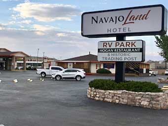
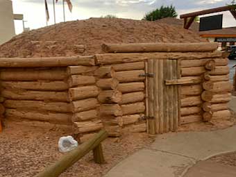
The eastern side of the well-named Navajo Bridge is the start of the Navajo Nation. We headed for the largest town, Tuba City (which was not named for a musical instrument - it bears the anglicization of the name of a Hopi man who allowed Mormon migrants to settle there). We checked into the NavajoLand Hotel, across the parking lot from which is a restored hogan adjacent to the old trading post.
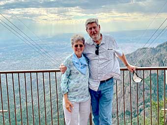
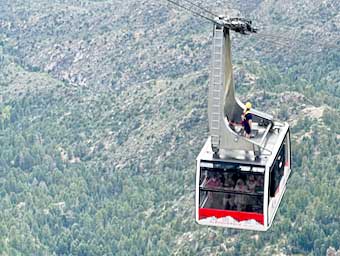
As Arizona yielded to New Mexico we headed to the edge of Albuquerque to check out the tram up to the 10,400-foot summit of the Sandia Mountains. The Sandia Peak Tram is the longest tramway in the world, offering closeup views of the mountain. The station on the peak provides the panorama you see behind us. Each of the tram car trips is accompanied by a “cabin attendant” who describes the sights while seeing to the safety of all concerned. The young man with that duty on our way up chose to ride back on the next car. Look closely: That’s him on the roof!
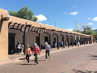
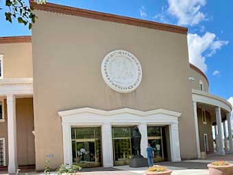
The amazing art colony, Santa Fe, is less than a hundred miles from Albuquerque. One of the earliest cities in the new world established by the Spanish, the town has a central square as required by The Laws of the Indies, issued by Spain’s King Phillip II in 1573. One side of the square is bounded by the Palace of the Governors which provides a block-long promenade now occupied by vendors of arts and crafts of the indigenous peoples. Outdoor displays of art abound although any real art lover will be drawn indoors to the numerous galleries despite mask requirements. Santa Fe is also the Capitol City of New Mexico, so we checked out the State Capitol building before heading on east.
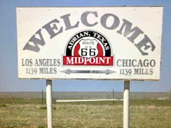
Once back on the road, we discovered many indications of local pride over having once been smack dab in the middle of America’s premiere highway, the legendary Route 66, which originally ran from Chicago to Los Angeles. In Tucumcari, New Mexico, there is even an art-deco monument to the route. Some 60 miles further along, as you move on into Texas, you can find an old sign marking the exact midpoint - 1139 miles from Chicago, 1139 miles to Los Angeles.
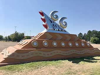
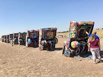
As you transit the panhandle of that giant state, you pass through Amarillo, home to one of the strangest “objets d’arte” we found on the entire trip. An art installation created in the 1970s as a nod to the evolution of the fins of Cadillac cars featured ten cars actually buried nose down in the good soil of Texas. It was moved nearer to the highway in the 1990s and somehow a tradition has built up of visitors spray-painting the cars - in fact, there is a trailer selling cans of spray paint on site. You can see by the photo that I’m not kidding!
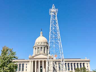
Driving on to Oklahoma City - with nothing much to see or do in between - we started our visit with a stop at the State Capitol Building. I suspect it is the only such building for any state in the union that has oil derricks on the grounds.
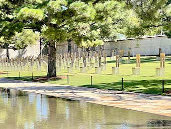
Before I retired from the Federal Government, I was a group leader in the GAO, Government Accountability Office, the neutral watchdog agency of the Congress. Oklahoma City to me has always brought to mind memories of the day in 1995 when a bomb took out the Murrah Federal Building killing 168 federal employees, citizens with business in the offices and kids in the day-care center. We had a branch office on the third floor and it was a long while before we, in Washington, found out that two of our staff had been hospitalized, but that none of our people had died because most were out of the building conducting interviews elsewhere.
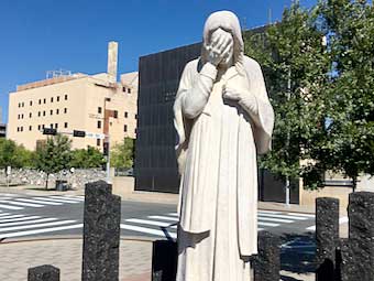
Thus it was an emotional visit for me when we pulled up to the memorial - especially when viewing the field of 168 empty chairs arranged in nine rows - one row for each floor brought down by the bomb. Twenty-eight chairs included six for the staff of our sister agency, the Defense Investigative Service, which was next to our office. But somehow the image that struck me the hardest was a statue across the street, on the site of the parish rectory of the St. Joseph Old Cathedral which was so badly damaged by debris from the collapsing building it had to be demolished. In its stead, a plaza was constructed with a statue entitled “And Jesus Wept” (from the shortest verse in the King James bible, John 11:35).
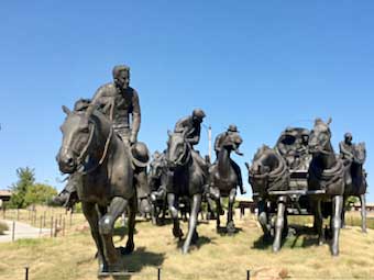
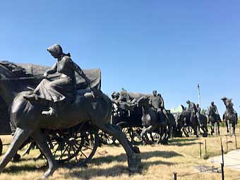
The Oklahoma Land Rush sculptures
A less somber set of statuary celebrates a momentous if troubling moment in American history, the afternoon of April 22, 1889. That was when land that had been reserved for tribes of indigenous people who had been dispossessed of their original tribal lands in the East was opened for settlement by non-tribal people - i. e. “whites.” Since, under the “Indian Appropriations Act of 1889,” anyone attempting to settle before the official opening would forfeit the right to homestead, some 50,000 people assembled on the border awaiting the sound of a gun at noon signaling the opening of the territory. By the end of that day nearly two million acres had been claimed and the hamlets of Oklahoma City and Guthrie, Oklahoma had each become cities of 10,000. The memorial takes the form of a line of sculptures depicting this land rush.
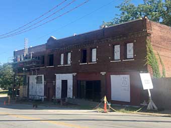
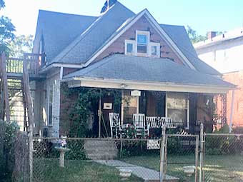
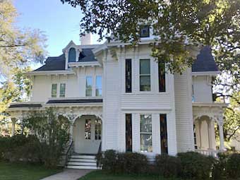
The highlight of our stop in Kansas City, Missouri, was tracing the start of the genius who made animation a cinema art form - and so much more - Walt Disney! Before he packed up and headed to Hollywood, he had established himself with a studio here in the midwestern city where he grew up. There has been an effort to restore the building that served as a studio where he produced Laugh-O-Grams, early cartoon short movies. It was here, he told an interviewer, that a “timid little brown mouse” was the inspiration for a drawing of a cartoon character that became known as Mickey Mouse. The building still needs a lot of restoration! Then we drove to the house that had been the Disney home at the time. It is a private home still … note the “private property” sign next to the gate … so we simply snapped a photo and drove on.
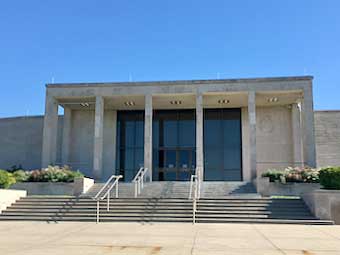
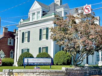
Next stop: Independence, home of the Harry S. Truman Presidential Library - the first of the Presidential Libraries we would stop by on our journey. It was built here because this is the town where he entered politics and where he lived before and after his presidency. Even during his presidency, he and his wife Bess, used their home here as “The Summer White House.”
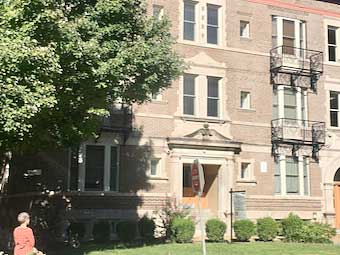
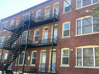
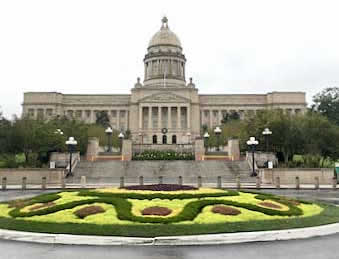
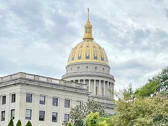
Speaking of homes, our best stop in St. Louis turned out to be the apartment house where playwright Tennessee Williams lived as a teenager, for it was here that he gained the memories which became his semi-autobiographical memory play “The Glass Menagerie.” That play, which features monologues by “Tom” (really Tennessee Williams himself) going out onto the fire escape to smoke the cigarettes his mother doesn’t allow in the apartment was even produced here during the pandemic with the audience in chairs in the alleyway watching the performers on the fire escape. After finding “The Tennessee,” as it is now known, we went around back to take a photo of the fire escape-equipped rear wall. Theater fans like me find such a connection to masterpieces thrilling. Continuing east on Interstate 64 we were able to visit two state capitol buildings in short order. Kentucky’s beautifully situated capitol on a hill overlooking the Kentucky River in Frankfort is only 200 miles west of West Virginia’s which overlooks the Kanawha River in Charleston.
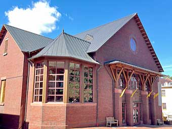
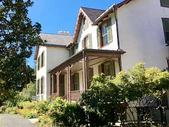
West Virginia yielded to Virginia where, in Staunton, we passed by the Blackfriars Playhouse, a recreation of Shakespeare’s indoor theater which now features the offerings of the American Shakespeare Center. While there, we stopped at another Presidential Library, although this one is a private non-profit operation rather than an official Federal facility. It is the Woodrow Wilson Presidential Library and Museum adjacent to the Wilson Family Home.
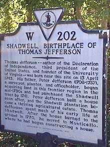
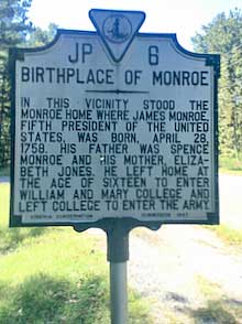
We pulled off the Interstate to pay respects, stopping at the birthplaces of both Thomas Jefferson and James Monroe. But not all the notable residences and birth places, of course, are of presidents of the United States. We drove along the Potomac River through the town of Colonial Beach where we spotted The Bell House, Alexander Graham Bell’s summer home facing the river.
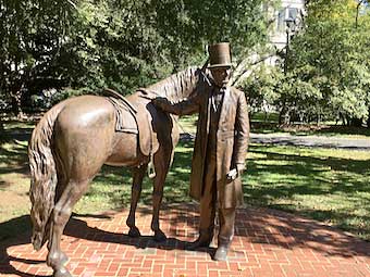
But we’ll end the trip with an even more important summer home - the Lincoln Cottage on the grounds of the Soldiers’ Home on the heights of North West Washington DC. It was here that Abraham and Mary Lincoln escaped the heat (and smell) at the White House along the banks of the Potomac during the warmer months. There is even a statue of Lincoln and his horse on the spot where he would mount up each morning to ride into town to his office in the White House.
For us, it was the end of the west-to-east portion of our crossing covid country. A little over a week later, we left to travel the other direction - which we’ll share next time.
|