I had tried numerous times to get to this point atop Calakmul’s massive pyramid known as Structure II, straining to locate a hump 34 miles to the south, just across the Guatemala border. In less than three months we’d be heading north from Flores via helicopter to that massive jungle- shrouded “mountain”, a.k.a. the Danta Complex at El Mirador, but for now we were exploring the Rio Bec region at the southern extremity of the Yucatan peninsula.
I had contacted my friend and intrepid guide in Guatemala City, Alfonso Muralles, telling him, “It’s time… Rio Bec… here’s want I to see… where do I meet you?” The result was a 4-day, 10.5-site itinerary, with a museum thrown in for good measure. This many ancient Maya cities would be possible in such a short time frame not because they were insignificant—far from it—but because this region was densely populated with important trading hubs, ceremonial centers and political powerhouses.
| |
 |
|
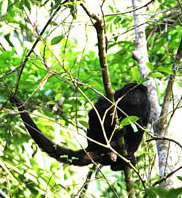
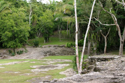
Much of the Rio Bec region lies within the Calakmul Biosphere Reserve, at 1.8 million acres (more than 70,000 square miles), Mexico’s largest tropical ecological reserve and one of the last rain forests in the Yucatan. It is home to howler and spider monkeys, ocelots, jaguars, pumas, and hundreds of exotic bird species. More than 1,500 varieties of plants flourish here, including several endangered species. Unlike most reserves which do not allow human habitation, around 5,000 people live within the Reserve. |
|
 |
|
| |
We met up in Chetumal, which stretches along the shores of its namesake Bay just north of the Belizean border. Capital of the Mexican State of Quintana Roo, it was an important port city for the Maya during pre-conquest times and remains so today. Despite my late night arrival, early the next morning we bid Chetumal farewell and headed east into the heart of the Rio Bec region.
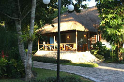
Our accommodations for the next few nights would be the Chicanna EcoVillage, centrally located for our exploration. Duplex bungalows provided all the comforts we needed, and the restaurant was conveniently situated directly across the cobblestone pathway from our rooms. Lounging on the outdoor deck in the evenings, enjoying our Cubra Libres, we were surrounded by strange jungle sounds which Alfonso had great fun trying to identify. At breakfast, we were serenaded by the melody of countless avian critters. |
|
| |
 |
|
 |
|
|
|
| |
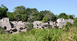
Built on some 15 square miles of hilly land, surrounded by jungle, Dzibanche was founded in 250 BCE and reached its peak during the Maya Classic period, 300-900 CE. A civic-ceremonial center, it is one Mexico’s most recently restored ruins. The Temple of the Lintels is an excellent example of a talud/tablero exterior. Also known as slope-and-panel, this architectural style is a platform structure, or “tablero”, built atop an inward sloping surface, or “talud”. |
|
| |
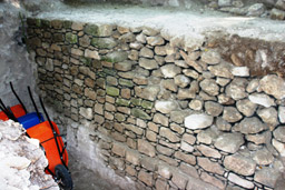
Tallest structure at Dzibanche is The Temple of the Cormorants, which encloses a royal tomb accessed by a hidden stairway. Current excavation work revealed a 1500-year-old wall. |
|
| |
A few miles away is Kinichna, thought to have been a suburb of Dzibanche. The stairway of the Acropolis, or Temple of the Sun, is flanked by two pairs of stone masks which conceal masks from an earlier construction. This is a common trait among ancient Maya buildings, where earlier structures are encased by later buildings. Two tombs found inside included some of the finest jade objects ever discovered in this area. |
|
| |
|
|
| |
Alongside the road about a half-mile from Kinichna are the remains of a massive acropolis at Lamay. While interesting, there wasn’t much else to see so I counted this as a “.5” (half) site visit. |
|
 |
|
| |
|
|
|
|
| |
 |
|
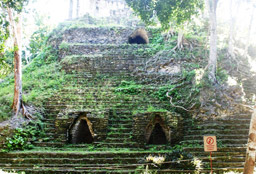
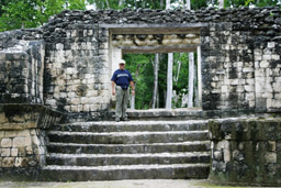
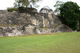
As you enter Kohunlich, a ceremonial center inhabited from 300-1200 CE, the massive Acropolis Plaza towers on your left, overlooking much of the site. This huge rectangular plaza is surrounded by four buildings |
|
 |
|
| |
|
|
|
|
|
|
| |
To the right of the Acropolis Plaza sits the Temple of the King. These views are from ground level and from the Acropolis Plaza. |
|
| |
|
|
|
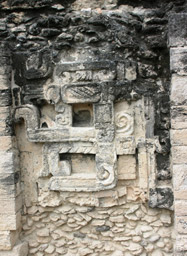
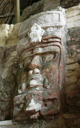
The Temple of the Masks is one of the oldest structures at Kohunlich. At nearly 50 feet tall, each side of its stairway is lined by ten-foot high carved stucco masks of the Maya Sun god, Kinich Ahau. Now protected by thatch shelters, these creations were covered by a later construction which preserved their exquisite features and remnants of their red color. Each mask is unique. Markings in the eyes of the one on the left show the hieroglyphic sign for "kin", Maya for sun, a cosmogram of the four cardinal directions. The mask on the right sports a bird-mask headdress with a jaguar mask under his chin, revealing him to be the Jaguar Sun God who traces the path of the sun across the sky. |
 |
| |
|
|
| |
 |
|
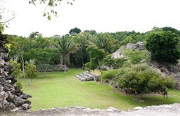
In the Sunken Plaza are extensive remains of a stucco floor. A complex hydro-engineering system channeled rainwater from 21 acres of this city into an massive reservoir, which allowed the ancient city to flourish despite the lack of a nearby water source. |
|
| |
|
|
|
|
| |
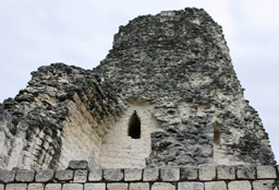
Just down the road from the Chicanna EcoVillage lies Xpuhil, which prospered during the Late Classic Period (400-900 CE) although there is evidence of a much earlier settlement. Its most impressive structure is the Building of the Three Towers. Typical of Río Bec-style architecture, it features a platform with chambers flanked by tall, solid towers, usually with perforated roof combs, giving the appearance of temples situated atop a pyramid. In this case, there are twelve rooms joined by three towers rather than the common two towers, each rising 30-40 feet. Mask panels border the doorways, some frontal views and others such as this profile. |
|
| |
|
|
| |
|
|
| |
Xpu-3 Central Tower - Tallest and best preserved is the Central Tower. Three stucco jaguar masks decorated this tower, this one the best preserved. |
|
| |
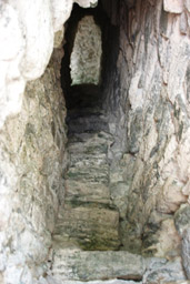
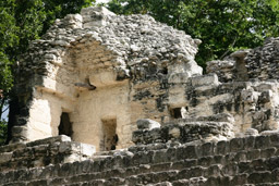
A narrow interior stairway in the South tower leads to a small room with a window. |
|
| |
| |
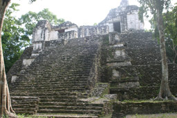
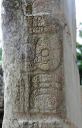
Maya scholars believe that during the Classic Period, the central Maya area was divided among four regional capitals: Copan, Tikal, Palenque and Calakmul, the latter being the primary rival to Tikal for dominance of the Peten region. It’s name glyph, pictured above, has been found at numerous sites including Caracol, Palenque, Yaxchilan, Piedras Negras, Naranjo, Waka and Dos Pilas. With an area of 42 square miles, it is larger than Tikal and the largest Classic Maya site ever recorded. More than 6,750 structures have been uncovered thus far.
Occupied from around 1000 BCE until the Spanish conquest, at the height of its power between 500- 850 CE, more than 50,000 people lived here. Towards the end it was inhabited by possibly more than 200,000 people. Calakmul is a World Heritage Site and an eco-archaeological park. |
|
|
|
| |
|
|
| |
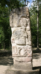
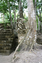
The site is renowned for the quantity of its stelae, with more than 120 carved monuments found thus far—more than any other known Maya site. It is also unique for the paired stelae depicting kings and their queens. Some are in remarkably good condition, as shown on the left above, and some are encapsulated in trees like the one on the right. Many are set in rows in front of buildings such as Structure XV, pictured above. |
|
| |
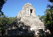
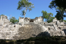
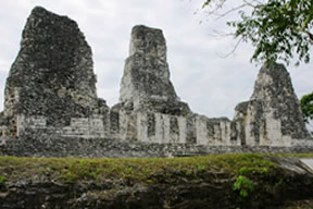
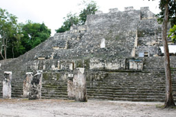
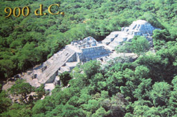
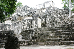
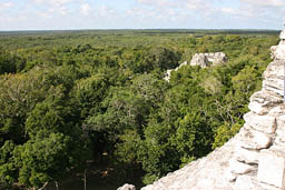
Soaring above the Grand Plaza is Structure II, the largest at Calakmul. It rises 180 feet above a pyramidal base. Four buildings are positioned on top, creating a small acropolis. The view from plaza level gives no indication of the massiveness of this construction. A long climb to the top makes it seem to stretch on and on. A poster in the visitor kiosk at Becan provided an aerial view of the structure, which I photographed so I would have a comprehensive view of what we had scaled the prior day. |
|
| |
|
|
| |
|
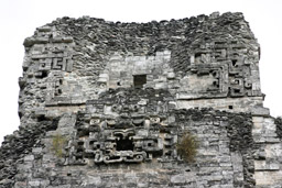
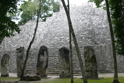
Structure IV is an example of what is referred to as an “E Group”, found in many Maya cities. These were celestial observatories comprised of an observation platform on the west facing a group of three temples on the east. Each of the three temples marks a position of the rising sun: the north structure indicates the summer solstice, the south marks the winter solstice, and the one in the middle denotes the equinoxes.
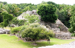
Covering more than ten acres, Balamku is little known beyond a handful of locals and archaeologists.
|
| |
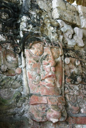
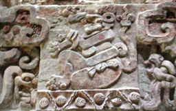
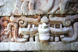
When the House of the Four Kings was excavated, a much earlier temple was revealed. Among its surprises was a 55-foot-long, 6-foot-tall stucco frieze of Mayan cosmology, much of its original red paint still vibrant. Among the many images portrayed are jaguar faces, amphibious creatures, and the challenging Earth Monster. |
|
| |
Heading back to our lodgings at Chicanna EcoVillage, Alfonso and I were still trying to absorb all that we had seen the past two days. We still had two days, four sites and a museum ahead of us. And an unexpected adventure in trying to reach the namesake site of this region, Rio Bec. Join me soon for “the rest of the story.”
Want to visit Mexico or Central America with an entertaining and endlessly enlightening guide? Contact Alfonso at Four Directions, www.FourDirections.com.gt or e-mail info@fourdirections.com.gt. He has a wide menu of set tours which explore the nature, culture and history of these countries, or he will help you design your own custom tour. |
|
|