| |
| |
|
|
|
|
| |
Malawi's Mulanje Massif is steeped in tradition, mysticism and witchcraft and as I headed towards the third highest peak in Africa the lead story in the national daily paper reported on the recent events that had taken place in the foothills of this vast granite monadnock.
There had been a worrying lack of rain for the time of year. The maize crops, that are so important across the country were already failing and the traditional authorities, village headmen and local communities had been accusing certain people of keeping the rain in their houses through the power of witchcraft. The consequences of these accusations had been fatal for these so called witches. The rain season is not the ideal time to go hiking on Mulanje but I was willing to chance it. Even with the small amount of rain there had been this year, I had heard how the area blooms with orchids, tall majestic grasses and lush green views.
I was on my final leg of a gruelling two day journey that had taken me from the north of the country on various coaches and mini-buses right down to the southern borders. I was exhausted before I had even started the trek. Finally we pulled into the dusty town named after the massif. |
|
 |
|
| |
|
|
Ttimber porter carrying his load down the Skyline Path |
|
| |
|
|
| |
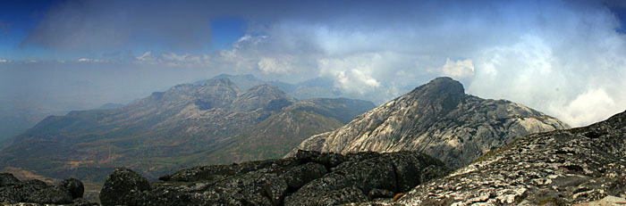
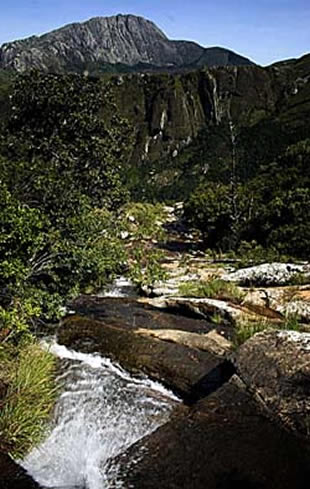
Mt. Mulanje was formed from igneous rock, an ancient block that cooled beneath the earth’s surface. Over time, softer rock has eroded away, leaving the isolated granite mass. One hundred thirty million years old, it is the highest mountain in south-central Africa, one of the world's largest granite inselbergs and has some of the best granite climbing you could hope to find. The massif is broken up by deep gorges down which rivers with spectacular waterfalls tumble. The mountain rises steeply and suddenly from the undulating plains to the highlands, surrounded by near-vertical cliffs of bare rock, many over 1,000m (3,280ft) high.
My first stop was the Mulanje Mountain office, situated at the far end of the main street that runs through the town. Here you can get information and advice on guides and routes. Having chatted with Richard, the manager of the office, and decided on my route, I just had time to get some of the irresistible, locally grown cashew nuts and bananas, before getting on the back of a bicycle taxi that would take me through the endless stunning tea plantations to the start of my trek. |
|
| |
|
|
| |
 |
|
We stopped at Likhubula Village at the end of the dirt road that leads to the Likhubula Tourism office and the park entrance. The guides and porters came running from all directions in the hope of selling their services. I had heard that the guides ran on a rotational basis giving them all work in turn, but this didn't seem apparent as I was surrounded by men franticaly competing for my business.
“I'm looking for Rex”, I stated repeatedly. Rex is a guide who had come highly recommended by some of his previous clients I had met some days earlier. It was not long until a young calm man casually walked over, shook my hand, and in perfect English introduced himself as Rex. His calm persona was a welcome relief compared to the ten or so guides and porters who had been maniacly shouting for the past five minutes.
As soon as we had negotiated a price, the other guides backed off and calm returned. We walked down past the sweet scented cedar wood carving stalls, selling beautifully sculpted walking sticks for the rambling tourists as well as some of the most impressive craftsmanship I've seen anywhere in Malawi. Having paid the remarkably reasonable park fees at the main gate, I was directed to the Likhubula Tourism Office to make my payments for the government-owned mountain huts. |
|
| |
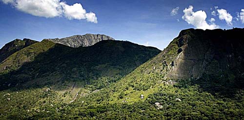
View of the Chambe Face |
|
|
|
| |
|
|
|
|
| |
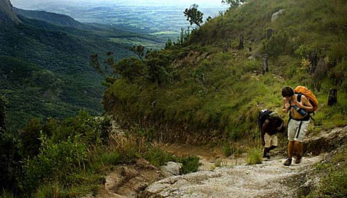
With our first day's hike from the CCAP Likhubula lodge, up the Skyline Path to the Chambe Hut, a predicted four-hour trek, we set off at a quick pace to reach our destination before sundown.
The trek started with a gentle rise through the pine forests. The invasive pine in this area is slowly being eradicated to make way for the famous Mulanje cedar. The Mulanje Mountain Conservation Trust is funded by the World Bank. Its aim is to provide long-term reliable support for biodiversity research and conservation. The area has a rich forest reserve, and is home to diverse endemic plant and animal species.
|
|
|
|
| |
|
|
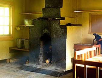
Inside the Chambe Hut |
|
| |
|
|
|
|
| |
Walking through this forest you are constantly reminded of the work that is going on to preserve the area. The route soon got a lot harder as the path got steep and wound through the forests of the unique Mulanje Cedar trees, some them over 200 years old.
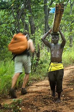
Because of the work going into the eradication of the pine, the forested slopes of the Massif support a sizable timber industry. We passed forest workers carrying up to four, five-metre planks on their heads. The planks are cut up in the forests by hand and transported in this way down the mountain.
Rex explained that they get paid around 50mk per plank, around 20p and they do up to three grueling trips per day. For years there was a cable-way to transport timber from the edge of the plateau down to the Likhubula forestry station but it fell into disrepair around two years ago. Locally, the rumours of the possible repair to the cable are unpopular as the employment in the local villages has risen dramatically since its demise. Many of the government-trained guides and porters do this work when they are not hiking with clients. |
|
| |
|
|
| |
|
|
| |
The path between Chambe and Lichenya Plateau |
|
| |
|
|
| |
The last hour took us on a more gentle path, through the Chambe Basin with the imposing sheer face leading up to the Chambe peak dominating the view. Rock climbers have been coming to this face for years for its challenging routes.
Threatening and dramatic clouds surrounded us but the rain held off as it had so often this season. Although considerably wetter up here than the plains below, the mountains would normally attract a lot more precipitation during the average wet season. Even the maize crops grown by the foresters, were looking small and dry. |
|
| |
|
|
| |
As we arrived at the Chambe Hut, our lodgings for the night, I was tired and hungry, but well rewarded. The watchman had a fire going and I cooked my pasta dinner watching the colours of the towering face change as the sun went down.
Although basic, all the huts on the massif are comfortable and with the fire blazing, warm and welcoming after the hard day's trekking. There are a range of fire-blackened cooking pots available but when the huts get busy, you will often have to wait your turn to use them. It is sensible to bring your own cooking utensils and plates. Simple plastic covered mattresses were supplied but it got surprisingly cold during the night and I was glad to have brought a good sleeping bag. |
|
|
| |
|
|
|
| |
Having rested well and after a hearty breakfast, we started our hike that took us up and down rocky paths, often flanking spring-fed streams and rivers with cascading waterfalls. We crossed huge plains and boulder fields, surrounded by dramatic granite peaks. Above the tree line, the long grasses, cycads and ferns give a Jurassic look to the landscape. Water bottles can be filled anywhere at this height and with the soaring temperatures they frequently were.
Chatting with Rex I learned more about the spirits that are believed to be so prevalent on this range. In recent years the mountains have claimed the lives of two tourists, both of whom were caught out by the weather after having decided to go into the range without a guide. He explained to me that if the body is never found, as in the case of a Dutch woman who was lost some years ago, then it is the work of the mountain spirits. The spirits aren't all bad though. Its believed that they commonly leave hot cooked food out on the paths, but if the well-fed walkers or workers are to mention their generous meal to anyone, then they will go insane within the week. The Mulanje district is known throughout Malawi for powerful witchcraft and you would be hard pushed to find any Malawian who doesn't believe in the spirits of the mountains.
| |
 |
|
 |
|
| |
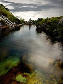
Linje Pools |
|
Linje Pools |
|
Unfortunately, we were not lucky enough as to be supplied a meal on the path so when we reached the CCAP hut, Hopes Rest, on the Lichenya Plateau, I set about cooking some food and resting on the balcony, treated to yet another striking view. Hopes Rest is the only non-government hut on the mountain and possibly the most comfortable. Built in 1904 it has real character and is the base for a short hike that takes you to the stunning Linje Pools. Sunset at the Linje pools was a true highlight. With a virtual sheer drop of 1000 metres to the plains below, the views stretch endlessly over the tea plantations and across to Mozambique. The crystal clear waterfalls are fed by the streams that come from deep crevasses across the grasslands of the plateau. Standing on the boulders with the water plummeting down the granite face below, it had to be one of the most dramatic and beautiful landscapes I have experienced anywhere in the world. |
|
| |
|
|
| |
After another comfortable night at Hopes Rest we had an early start. For many of us there is always a strong urge to make it to the peak of any mountain range, and Mulanje is no different. First we had to make it to the Chiespo Hut. From here you can reach Sapitwa, the highest point of the massif. We set off at a rapid pace and by 10am we had retraced our steps from the previous day up until the last hour where we branched off right and after gently climbing for an hour we reached the hut.
As they had been for the whole trip so far, the weather gods were on our side and Rex gave us the go-ahead to make the steep climb to the Sapitwa, the peak, but not without a firm warning. We needed to keep up the necessary pace to ensure we would be back at the hut by 5pm. Lightening our load, we left non-essentials with the watchmen and set off for the summit.
The start of the climb was a 40-degree, scree-covered granite slope. It proved to be the hardest part of the climb and made me realize how dangerous it would be in the wet, both on the assent and decent. It was becoming clear as to how weather-dependant reaching the peak was. Beyond this we hiked through endless boulder fields, scrambling over rocks with short but challenging climbs. After two and a half hours we had reached the summit. |
|
| |
|
|
|
| |
|
Sapitwa, translates as 'don't go there', and I certainly was not going to agree with that. Standing at 3,001 metres it is marked by a simple post. With stunning views, I could see across the whole range of over 20 peaks, protruding through the clouds that chased through the valleys and raced up the slopes before dispersing into the deep blue sky. The sights were short-lived as Rex was concerned about the weather front that was obviously coming our way.
Having covered such a distance that day, the descent was gruelling and my legs were burning as we negotiated our way down. Safely back at the hut and after a much needed feed, the rains came with vengeance and we were treated to a spectacular lightning storm flashing through the darkness. I was more than ready for my last night's sleep in the mountains and however loud the thunder clapped, there was no chance of it disturbing me. |
|
| |
|
|
|
| |
The next morning the trees and grasses glistened in glorious sunshine. The steam was rising all around the hut as the sun evaporated the the rains. The landscape was overwhelming and the thought of leaving didn't appeal. I had been warned that the final trek down, to Likhubula Village was hard and the long steep descent really took its toll on my knees forcing me to stop many times to allow my tendons and muscles to relax, but giving me time to take in the glorious views of the mountains towering above.
The descent became more manageable as we walked back down through the deep green tea plantations, punctuated by the brightly-dressed pickers. We finally reached the sprawling village where we had started our journey three days earlier. As we ambled back into Malawian civilisation, past the hoards of excited school children, I looked back at the mountain range that had given me some of the best hiking I have ever experienced.
Once in Malawi, the costs of trekking on Mulanje, unlike other mountains in Africa, are unlikely to break the bank. Permits for the massif are 100mk (40 p) per day and are obtainable from the gate in Likhubula. Just through the gate you will be directed to the office where the hut fees can be obtained. The price varies depending on the time of year but it should never cost you more than 250mk (£1) per night. Maps of the range are also available from here.
You can expect to pay around 1500mk (£6) per day for your guide and 1000mk (£4) for porters. Your guide may also be willing to serve as a porter for an extra cost and will often cater for groups if this has been pre-arranged. You can expect to have to give the guides some money in advance for the purchasing of their own food for the trip and don't be shy to tip if you are happy with their services afterwards. They are all government trained and generally very knowledgeable, making the mountain experience a far more interesting one.
Not all guides are prepared to do Sapitwa peak so if this is your intention, check in advance. It's advisable to come well-prepared—supplies for your trip are best bought in Blantyre.
There is a large network of paths linking nine huts and the route that you choose will depend on your ambitions for your trip. Choices can be varied—attempting to reach the Sapitwa summit, hiking through the forests and hiking along the mountain plains. Your guide will be able to discuss and plan routes with you.
Huts can only be booked upon arrival at Likhubula. In the event of an emergency, the Forestry Officers at Likhubula are responsible for co-ordinating any search and rescue operations that may be required. In extreme cases the army has been known to use helicopters for search and rescue. Mobile phone reception is available throughout most of the massif.
Being typically tropical, the best time to visit is between mid-April and August when it’s dry and temperatures are moderate. Although I was lucky, November to early April is generally hot and wet while September and October are traditionally hot and dry. The Afromontane habitat includes grassland and cedar forests. There are two types of cedar—the Mulanje cedar, Widdringtonia whytei, which is endemic to Mulanje, and Widdringtonia nodiflora. Large and small varieties of gladiola, a colourful array of ground orchids, and proteas also adorn the mountain. Aloes are common on the upper slopes of the peaks. Chrysanthemum, wild peach and yellow wood also all occur. Bird life includes purple-crested loeries, larger raptors, cisticolas and kestrels.
Ethiopian Airlines, Kenya Air, South African Airlines and Air Malawi all fly in and out of Lilongwe, the capitol city around 300km to the north. South African Airlines, Air Malawi and Air Zimbabwe fly into Blantyre Airport 60km to the east.
Several car rental companies operate from both airports but prices can be expensive. Malawi has relatively good roads and 4x4's are rarely necessary. Alternatively, there are comfortable coaches available from Lilongwe to Blantyre, km north. From Blantyre there are less comfortable minibuses that will take you to Mulanje. From there you can easily and safely hitch hike or catch a bicycle taxi to Likhubula.
Serious climbers and those wanting organized tours can pre-arranged through:
Jambo Africa Ltd, Shop 1, Sunbird Mount Soche Hotel, Glyn Jones Rd. P.O. Box 2279, Blantyre. Tel: +265 (0)1 823 709; Fax: +265 (0)1 823 709. E-mail: jamboafrica@africa-online.net Web: www.jambo-africa.com |
|
| |
|
|
| |
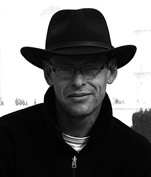
Al recently returned to the UK after travelling throughout India, Nepal and Africa for several years. For the last two years he lived in Malawi building adventure playgrounds in schools and hospitals. Doing this independently of any organised charities, Al basically turned up with some savings and when they ran out, sold photos to travel publications and sought financial help for the playgrounds from a Rotary Club back in the UK. He would gather up as many of the local tourists as he could persuade to help, and build large playgrounds involving the local communities in every way possible. For Al, it was an inspiring time living and working in such a beautiful country. |
|
 |
|
| |
Alexander Bruce can be reached at al9bruce@googlemail.com |
|
The author |
|
|
|