Exploring Western Ireland’s Dingle Peninsula
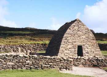
"There’s not a trace of mortar holding these stones together, but it’s completely waterproof!" exclaimed my wife as she peered through the doorway of Gallarus Oratory. The too-small doorway and a foot-square window provided meager interior lighting. Shaped like an upturned boat and intact in its original condition, the oratory was constructed about 700 A.D. as a church by Ireland’s early monastic Christians. The monks had utilized the Celtic art of layering successive strata of stone with an outward tilt to shed water, each layer bending slightly closer and narrower towards the peak.
|
We were slowly exploring the Dingle Peninsula, Ireland’s westernmost tip. The archaeological wonders and desolate coastline beauty had grown more mesmerizing with each bend in the one-lane road. Numerous Iron Age beehive huts and forts sat perched on steep green hillsides overlooking white racing Atlantic waves and the windswept Blasket Islands. With tiny Gaelic-speaking Dingle Town as our home base, its narrow streets lined with shops and folk-music-filled pubs, we knew we had found Ireland’s most entrancing region.
Alluring History
Man’s earliest roots in this region have been traced back 4,000 years to the Bronze Age. Although little remains from those years, many relics from Ireland’s Iron Age (1,000 B.C. to 500 A.D.) still dot the landscape, including Ogham stones with early Celtic writing, ring forts, and beehive huts. They date from a time when Ireland was divided into Celtic provinces, each with its own king and clans governed by local chiefs.
In the chaos of the Dark Ages following the fall of the Roman Empire, peace-loving educated monks fled the Continent, sailing in the 5th and 6th century to Ireland at the fringe of the known world. One of their settlements was on the Dingle Peninsula where the ruins of the Riasc Monastery still remain. The monks worked well with the resident Celts, and they kept Christianity and literacy alive in Europe. This period continued until the Normans invaded in the 12th century and established larger church and state governments.
Colorful Dingle Town was a busy, walled Norman seaport in the late Middle Ages. Locals traded cowhides for wine with Spain, three sail-days away. In the 1800s Dingle Town became known as a linen-weaving center and fishing port. The peninsula’s farmers have traditionally raised stock, grain, and potatoes and were hit hard by the blight and famine of 1845.
|
|
|
Since the movie Ryan’s Daughter introduced the world to Dingle in 1970, visitors have increased steadily. It's no wonder -- the Dingle Peninsula holds onto its alluring roots. It is one of the few Gaeltactht regions where the government subsidizes the survival of the Gaelic language and culture. The schools, road signs, and menus all come in Gaelic, although the residents gladly speak English for the welcome visitors.
An Enchanting Loop
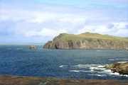
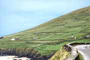
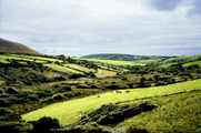
Slea Head Drive, a one-way, single-lane loop around the far-western end of the peninsula, leaves from and returns directly to Dingle Town. The 30-mile tour can be done in a half-day by auto, or a hard-cycled full day by bicycle. This is rugged, desolate country. The residents reclaimed the land with painstaking labor, clearing the stones, building stone fences, and transporting seaweed and sand to improve the clay soil. From one viewpoint we saw fields high up on a hillside where potato bed ridges still lay untouched since the fated planting of 1845. At other points we gasped at breathtaking panoramas of the coastline with steep cliffs falling into the sea, isolated beaches, and the Blasket Islands. These natural wonders and the following array of historical sites made this day of explorations our most enchanting in Ireland.
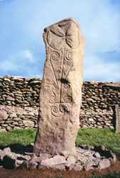
| Ogham Stones: Dating from 300 A.D., these stones near the village of
Ventry contain rare examples of early Celtic writing. Utilizing variations of five
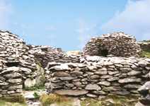
straight lines, the Celts used a writing alphabet of 20 different letters. Ring Fort and Beehive Huts: Clustered within a circular stone wall is a group of beehive huts, essentially stone igloos, which provided shelter for small families from 1,000 B.C. to as late as 1200 A.D. We climbed the steep hill up to this old settlement and felt that there was no better way to appreciate the hard livelihood earned by Ireland’s Celtic civilization. |
|
Dunbeg Fort: Perched on a sheer cliff promontory, this hill fort contains a stone rampart and entrance, guard chambers, underground tunnel, and central beehive hut. Although inhabited as late as the 11th century, evidence of early settlement dates back to 500 B.C.
|
Great Blasket Center: This modern facility is a heritage center for Gaelic
culture and a memorial to the hardy souls who inhabited Blasket Island up until 1953. The
small community of approximately 100 had survived for centuries, each family owning a cow,
several sheep, and a small potato plot. Riasc Monastery: Dating from the 5th to the 12th century, the monastery site lays in ruins with traces of walls, inner walls, beehive hut residences, a square oratory, and an outside grain kiln operated for the surrounding farmers. An incredible Celtic pillar stone dates from 1,000 B.C., with a monk-carved Maltese-type cross, inscribed over the Celtic scrolls. Gallarus Oratory: one of Ireland’s best-preserved early churches (700 A.D.) |
Friendly Dingle Town
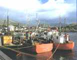
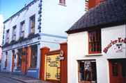
Thirteen hundred of the peninsula’s 10,000 residents live in Dingle Town. Its gaily-painted homes, shops, and pubs line the few streets that run up from the always-busy fishing harbor. There are a number of B&Bs throughout the town and across the harbor where we stayed in the Milltown B&B. It was Robert Mitchum’s home during the filming of Ryan’s Daughter. Friendly Mark and Anne Kerry, long-time Dingle residents who run the B&B, related some of the interesting folklore and recent history of the area.
|
|
|
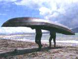
The Dingle Marina Center offers diving, sailing, and currach rowing. Currachs are Ireland’s traditional lightweight fishing boats, made with tar-covered canvas over a wooden frame. We enjoyed a bay row and of course an evening town pub-crawl. Dingle Town has 50 pubs, many which host excellent Irish folk-music groups. Our favorite places were O’Flaherty’s on Strand St. and the nearby Small Bridge Bar on Main St. Our best Irish meal came at Doyle’s Restaurant on John St. where we could heartily attest that seafood was their specialty.
Dreams of the Emerald Isle
Folk fairly tales, like the film, The Secret of Roan Innish, were born in places like Dingle. The Peninsula, its people, and its archaeological wonders captured our Irish dreams with images of closeness to the land and the sea that are at the very core of Irish culture.
Click here for details to plan your own trip to Western Ireland.
Les Furnanz
Photos by Rita Furnanz