|
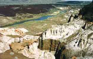
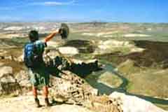
From the cliffs above, the river seemed a thinly curled blue ribbon
laid atop the see-forever desert. Gradually, the narrowing whisper of water furled,
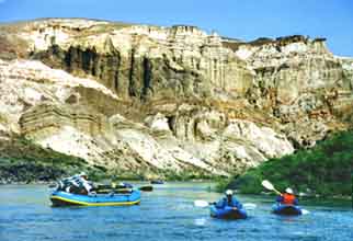
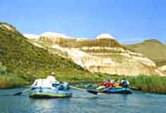
evaporating in an expanse that appeared eternal. The next day, from water level, the lofty battlement-like aeries where we had stood rose over the Chalk Basin, climbing steeply skyward until being swallowed by an intense azure sky. The basin's erratically colored, banded cliffs and pinnacles disappeared as our flotilla of rafts and inflatable kayaks silently glided down our meandering waterway, the Owyhee River. |
Mention the Owyhee and most folks get perplexed. Ow-ya-hoo? It's pronounced O-waa-he, as in Hawaii. Before 1800, Owyhee was the name used for Hawaii. The river was named for emigrant trappers from Hawaii who were killed by Indians while scouting the region in 1819. The river rises in the outback reaches of southwestern Idaho and northern Nevada before curling into far southeastern Oregon.
Remote? Definitely. The Owyhee's seasonally navigable sections are reached from the high desert communities of Three Forks and Rome, pinpoints that look bigger on the map than in person.
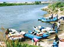
| No dams meter the flow of mountain snow melts that fuels the Owyhee, so the normal float season is March through May or early June. By late summer the river is a trickle. In 1984, Congress designated 120 miles of the Owyhee - from the Oregon-Idaho border to the Owyhee Reservoir - as wild and included it in the National Wild and Scenic Rivers System. Wild is the Lower Owyhee, but not in the tradition of frothy, churning whitewater. The Lower Owyhee's lure focuses around its mostly friendly rapids, geologically fantastic scenery, and all-embracing solitude. The Rome to Owyhee Reservoir section, a 67-mile section that is usually traveled in four to six days, is challenging but not daunting. The Lower Owyhee has its rapids, but it's not a river to travel rapidly. |
|
No White-Knuckle Rapids
"It's a canyon trip. There aren't white-knuckle rapids," explained Ron Pribble, owner of Cascade River Runners, of floating the Lower Owyhee. "I get this amazing sense of being 'out there.' You get in the rhythm of being on the river and in the canyon, of being unplugged from the pace and race of life." Depending on the winter snow pack, Pribble and other outfitters offer three or four five-day trips for up to 16 people each season.
As I learned, the Owyhee's moods shift and vary. The first few miles from the launch site it flows past agricultural lands before passing the Walls of Rome, rampart-like cliffs of compacted volcanic tuff. In the following few miles the river winds and curls, sometimes in the shade of steep-walled canyons, often through regions where the canyon temporarily flattens and creates sandy beaches for overnight camps. At one camp, we took an evening hike, spiraling past steep towers to the mogul-like high prairie. The desert plains stretched for miles, flanked to the west by snow-topped Steens Mountain while eastward the river canyon disappeared like a dagger in the wilderness.
|
|
Traveling Wet Highways
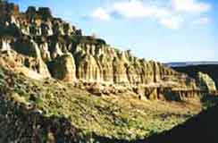
Rivers are wet highways. The Owyhee, one of the West's least known liquid arterials, is a river traveled by rafts and rubberized inflatable or hard-shelled kayaks. Its roadside attractions don't include burger stands or malls. Instead you’ll find places of natural wonder: Weeping Walls, where freshwater springs seep down vertical walls; springs so hot that it's necessary to cool them with bucket loads of river water; petroglyphs chipped into flat-faced basalt blocks; caves that still harbor fractured remnants of long-ago Native Americans; petrified trees with stumps frozen into rock; and towering cliffs, some with tops rounded into domes, others frazzled with scarred walls and blobs that look like spilled paint.
We counted numerous birds, at least 45 species. Golden eagles, usually in pairs, routinely flew overhead. A nest-protecting kestrel dive-bombed a nonchalant raven. Killdeer and dippers cruised just above water level while terns plunged after fish, seemingly out of control. Flowers speckled the waterway, but created more prolific gardens on the upper ridges. One day we identified two dozen types of flowers, and puzzled over half that many others. A pinch of brilliantly blooming purple sage released a desert aroma. Four kinds of lizards variously appeared. The best was a banded lizard that sat statue-like within the bowl of a rock mortar. Another defied us with steely eyes as it slowly swallowed another smaller reptile.
More Tempting Treats
|
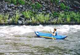
We ate more tempting meals. Pribble and his crew fixed bagels, granola, yogurt and pancakes; cheeses, meats, crackers and fresh fruits, shrimp stir fry, strawberry shortcake, chicken fajitas. An anthropologist generously explained geology, archeology and, one night, the fine art of flint knapping. Pribble, an English professor, orchestrated the traveling band with his wife, Lan. On our trip they also pampered clients from Carson City, Nevada. The adults gathered on one paddle raft while their frisky children frolicked on another. My family and I split time on rafts and inflatable kayaks. Inflatables were a kick. Rapids that appeared from a raft as mere riffles seemed proportionately higher from water level. |
Despite the generally peaceful waters, we had a few thrills. At Artillery, a rolling riot of standing waves, a pair of kayaks ahead of me bounced like bugs. A day later at Montgomery, the Lower Owyhee's most difficult rapid, I paddled a passage alongside a rocky chute and swooped through a water-soaking hole before - oops - I realized I wasn't wearing a life jacket. Low water simplifies some rapids but complicates others. One young kayaker flipped on the second of a series of rapids. Two apprentice rafters smacked the wall and spun recklessly in Montgomery. Another raft slid awkwardly though a rock-clogged rapid, and, worse, a cargo-hauling raft flipped.
Final Challenge
A different challenge was the final stretch, miles of relentlessly flat slack water. At the south end of Lake Owyhee the rafts were tied together and an outboard motor, hauled for this reason, materialized from the mounds of baggage and oh-so-slooooowly puttered our floating caravan 13 miles to the Leslie Gulch take-out. From there a gravel highway passed through the whacked-out rock formations of Leslie Gulch before turning to pavement for the ride to Jordan Valley and, eventually, home.
Sure, paved highways serve a purpose. But the Owyhee River and its treasures can only be seen from its seasonal, seldom-traveled watery route.
|
|
Click here for details to plan your own trip down Oregon's Owyhee River.
Lee
Juillerat
Article and photos