| |
Stunning Crater Lake
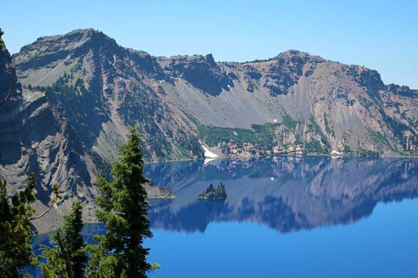
Summers at Crater Lake National Park have become increasingly busy, with swarms of visitors easily outnumbering mosquitoes. That’s because nearly everyone who visits Oregon and the Pacific Northwest plans a first-ever visit or got-to-see-it-again trip to Crater Lake. The allure, of course, is the incredibly cobalt blue water of the lake inside the caldera of Mount Mazama, the Cascade peak that literally blew its top 7,700 years ago.
Many regard late summer and fall, when the crowds thin and the temperatures cool, as the best time of year for enjoying the park’s many diverse offerings. But be prepared, because atop the Oregon Cascades, snow can create a blanket of snow by late September or into October.
| |
 |
|
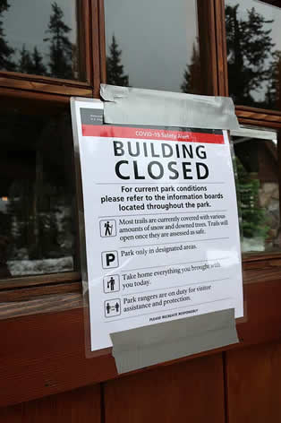
The COVID-19 pandemic forced the closures of several of the park’s popular activities, including concession-operated, ranger-guided lake boat tours and stopovers at Wizard Island. Also absent are ranger-guided hikes, campfire talks, and access to visitor centers.
It’s still possible to view the lake from vantages at Rim Village, overlooks along Rim Drive or, even better, from lake level. But for more than a quick drive through, you can take the time to view, explore and learn the history of some the park’s lesser-seen sights. It’s quick and easy, for example, to make the short walk to the headwaters of Annie Spring, get off the main tourist route by driving the Pinnacles, or solve the riddle of how the Goodbye Creek picnic area got its name. |
|
| |
Most Crater Lake facilities are closed |
|
|
|
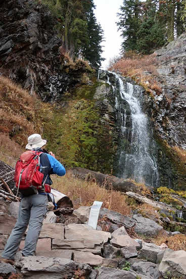
Cleetwood Cove
The Cleetwood Cove Trail, the only path that reaches the lake, descends 700 feet from the Cleetwood Cove parking lot. The 1.1-mile walk down is easy, but be prepared for the feels-like-a-Himalayan-climb back up.
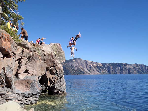
Jumping into Crater Lake
The reward at the end of the hike down is experiencing the lake at lake level. Disappointedly, because of closures stemming from the COVID-19 pandemic, no lake boat tours were offered this summer, which also means no access to Wizard Island. (If you haven’t taken a boat tour add that to your to-do list for a future visit.) The hike is still worthwhile because the lake-level views will leave you with a gee-whiz appreciation for the eruptive events that turned a mountain into North America’s deepest, clearest lake.
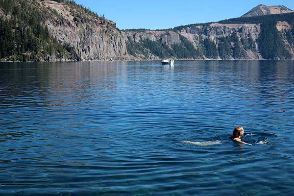
Enjoying a Crater Lake swim
Once at Cleetwood Cove, you may want to consider experiencing the lake by taking a quick swim. Yes, the water is cold, but the opportunity to swim in a caldera is unique. Swim on either side of the boat dock or, even better, move on to a cove just up the trail past the restrooms. Or dive/jump in from a perch above the lake. To make the climb out refreshing, get wet just before leaving. Then take advantage of benches to rest, drink lots of water and enjoy lake views.
The Watchman
| |
 |
|
 |
|
| |
Crater Lake from The Watchman |
|
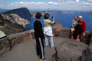
Picturing a memory |
|
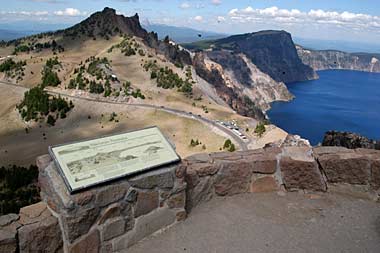
For sky-high panoramic vistas of the lake and surrounding mountains, the choice is The Watchman. The trail begins from the Watchman Overlook parking lot. It’s about three-quarters of a mile and 656 vertical feet to the lookout. The trail has several switchbacks as it steadily but gradually works uphill, with several overlooks. Once on top, with the help of interpretive signs, check out neighboring landmarks like Mount Thielsen, Union Peak, Mount McLoughlin, and Mount Scott. And remember, unlike the Cleetwood Trail, the way back is all downhill.
Lightning Spring
| |
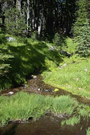
Among the park’s least traveled trails is the Lightning Spring Trail, which begins near the well-signed Lighting Spring picnic area along West Rim Drive. It’s only about three-quarters of a mile with an elevation loss of 250 feet to the spring, which unceremoniously pops from the ground and becomes a gentle creek. Just like the trail itself, the adjacent backcountry campground is sparingly used. The hike meanders in large sweeps through meadows. It’s not uncommon to see grazing deer and, depending on the time of year, fields of wildflowers. |
|
 |
|
| |
|
|
Little Seen Lightning Spring |
|
Castle Crest Wildflower Garden
| |
 |
|

|
|
| |
Fields of flowers |
|
Lewis Monkeyflower |
|
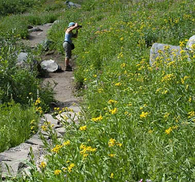
A very easy, seasonally beautiful trail loops around the Castle Crest Wildflower Garden. The hike begins from a trailhead just off the East Rim Road near park headquarters in Munson Valley. In less than a half-mile the trail circles a meadow that’s seasonally bursting with, as the name indicates, multi-varieties of Indian paintbrush, Penstemon and the showy Lewis Monkeyflower, along with Red Columbine, Creeping Phlox, Shooting Star and Scarlet Gilia.
Lady of the Woods
Historic Lady of the Woods
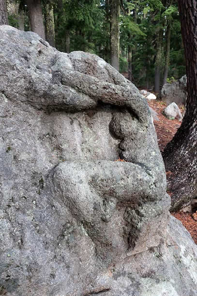
An easy hike that showcases some of the park’s historic architecture is the short Lady of the Woods Trail. The loop trail goes less than a mile from the Steel Visitor Center, which is currently closed because of the pandemic. The main attraction is “The Lady,” the sculpture of a woman carved into a boulder alongside the trail. Some people walk to the Lady then return, but it’s worthwhile to finish the loop to see many of the park’s historic buildings. If available, an excellent park brochure provides details about the Lady and buildings.
Sun Notch
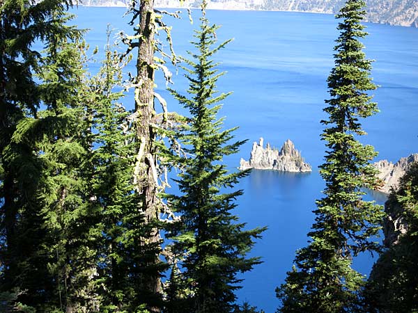
The Phantom Ship from Sun Notch
Views of Crater Lake and the Phantom Ship are among the lures of the Sun Notch Trail. The loop trail begins along East Rim Drive 4.4 miles east of park headquarters and goes through a meadow to the lake’s rim. The U-shaped valley was carved by glaciers that eons ago flowed down from Mount Scott.
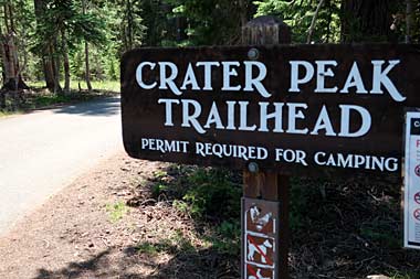
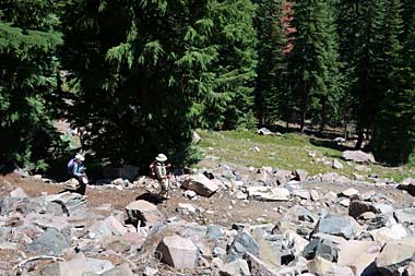
Crater Peak
| |
 |
|
 |
|
| |
Sign points the way to Crater Peak |
|
Hikers on the Crater Peak Trail |
|
Crowds aren’t seen on the Crater Peak Trail, a trail that ironically offers no peeks or views of Crater Lake. It’s a nearly seven-mile roundtrip to the peak and around the crater from the Videa Falls/Crater Butte Picnic Area off East Rim Drive. The trail passes along a watery, flower-filled meadow before climbing a steep, loose rock section, then through gentle forests and meadows, on its way to the cinder cone, where some sections of the summit bowl are beautiful, grass-filled meadows and other sections, which feature ragged trees and often stunning views of Mount Thielsen, Mount Scott, Union Peak, Mount Shasta and Mount McLoughlin
Annie Spring
| |
|
|
 |
|
| |
Annie Spring bursts from an unseen aquifer |
|
Annie Spring trail meets the PCT |
|
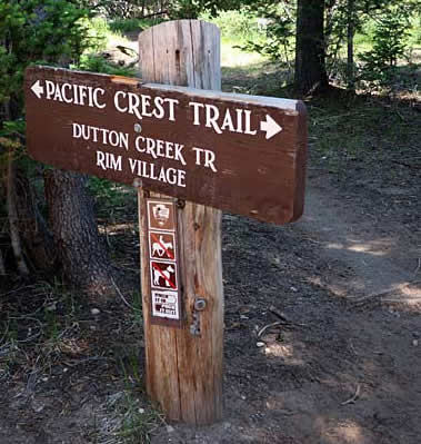
An easy hiking choice is possible shortly after entering the park’s Annie Spring entrance station. Instead of immediately driving up to Rim Village, at the bend in the road just before crossing a bridge, park at a pullout on either side of the road. Walk down to the spring, which sends a continuous blanket of water that carves its way down Annie Creek Canyon. Several viewpoints along the highway between the park’s south entrance and Fort Klamath offer dramatic views of the creek and canyon.
For a longer visit, follow the trail north a half-mile to a junction with the Pacific Crest Trail. The trail left goes towards Highway 62 but, instead, take the trail to the right, which curls around Munson Point and in about 1.7 miles reaches another junction. From there, follow signs to the Dutton Creek Campground, a great turnaround spot or place for a picnic before retracing your steps.
Plaikni Falls
| |
 |
|
The Plaikni Falls Trail is a mile-long, wheelchair-accessible, family friendly hike that’s proven especially popular. The end reward is a view of the 35-foot high falls. The name Plaikini honors Klamath Indians, who for generations lived in and near lands included in the park.
The trail crosses a pumice flat before tucking alongside rocky bluffs, where it’s common to see soaring red-tailed hawks. Nearly a mile into the mostly gentle walk, the trail angles uphill through a meadow and riparian area seasonally bursting with grasses and a rainbow’s array of wildflowers — Indian paintbrush, Lewis Monkeyflower and Arrowleaf Groundsel. Just a short distance upstream the Plaikni Trail ends at the falls. The trail begins from the Pinnacles Road 1.2 miles southeast of the Phantom Ship Overlook. |
|
| |
Viewing Plaikni Falls |
|
|
|
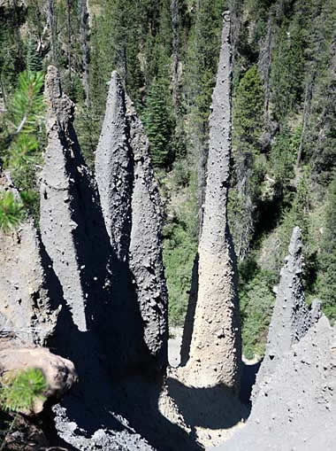
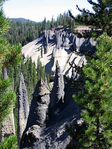
The Pinnacles
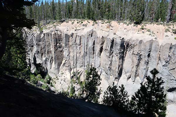
Guardian walls along Wheeler Creek
Plaikni Falls is a delight, but so are the Pinnacles. To reach them, drive past the Plaikni Falls Trailhead to the end of the Pinnacles Road. Along the way are views of the guardian-like walls that line Wheeler Creek. At the road’s end, the formations transform to a wonderfully weird series of needle-like spires.
The evocative Pinnacles are solid rock pillars
Geologists explain that the pinnacles were created during Mount Mazama’s cataclysmic eruption 7,700 years ago. As Mazama collapsed, fiery avalanches of high-speed superheated ash spewed down Mazama’s flanks, filling Wheeler and Sand creeks. Inside the flow, the gases welded the loose ash into solid rock pillars. Over millennium, the creeks eroded most of the loose ash, revealing the formerly hidden hardened vents as these evocative formations of spired pinnacles.
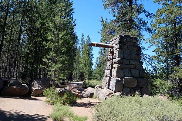
The Old East Entrance monument
From the parking area it’s an easy half-mile walk through a lodgepole pine forest and along the creek to the stone monument that marks the location of the park’s former East Entrance. The sign is gone, but the stone boundary marker built by Civilian Conservation Corps crews in 1937 remains. The entrance was closed in 1956 because of low use. It reopened from 1971 to 1973, when it was permanently closed.
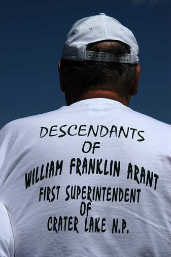
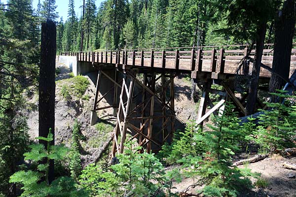
Goodbye Creek
The Goodbye Creek Picnic Area isn’t so much a dazzling sight to see as it is a tidbit of the park’s human history. The creek is crossed by one of the park’s only two bridges—the other crosses over Annie Spring and Annie Creek. The first Goodbye Bridge was built in 1913. The current bridge was built in the 1950s after the original collapsed in 1942.
| |
The name, “Goodbye,” stems from a year-long battle that began in 1912 when efforts were made to oust William F. Arant, Crater Lake’s first superintendent. After a series of politically motivated disputes, Arant was forcibly removed in July 1913 by US Marshal Leslie Scott. According to newspaper reports, when Arant refused to comply with a deadline requiring him to leave, “Arant told Scott, ‘I would like to see somebody try and remove me from my own house.’ However, in less than one minute he (Arant) was passed through two doors and landed in the front yard. He returned immediately and was again ejected without ceremony but with dispatch.”
It wasn’t a smooth transition. Along with intense political bickering, there were threats, an alleged fist fight, and, eventually, in 1917 a US Supreme Court decision that upheld Arant’s ouster.
According to the story, Arant later returned with friends, forced his way back into his office, and was ejected four more times. Arant, his wife and his brother, who was helping to build the then unnamed bridge, camped at the park while William Steel, known as “The Father of Crater Lake,” assumed duties as superintendent and moved into the Arants’ former home. The paper said the Arants were granted permission to remain “until the bridge upon which the Arants have been working on is completed.” |
|
 |
|
| |
|
|
The Arant family remembers their namesake |
|
The “Smith Brothers History of Crater Lake” tells, “A creek in the park where the (Arant) superintendent and his brother had been building a bridge was given a poignantly appropriate name at the time of their departure: ‘Goodbye.’ As US Marshal Leslie Scott bid ‘goodbye’ to [the] Arant family, he named a bridge and a creek beneath a bridge ‘Goodbye’ because it was the last piece of work completed at Crater Lake by the ‘retiring’ Superintendent.”
The Goodbye Bridge
When driving between the South Entrance and Rim Village, take a moment to say hello to the Goodbye Bridge.
When You Go
Because of the ongoing COVID-19 pandemic, visit the park’s website at www.nps.gov/crla
or call 541-594-2211 for updated information. Several National Park Service facilities, including visitor centers in Munson Valley and in Rim Village, are closed. Ranger-led programs and hikes are not being offered.
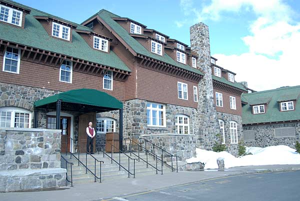
The Crater Lake Lodge is open only to guests
Concession facilities, including the Annie Creek Gift Shop/Restaurant, Annie Creek Cabins, Mazama Campground and Rim Village Gift Shop/Restaurant, are open with some reduced food service options. The historic Crater Lake Lodge is open but only to lodge guests. For updates, visit the Crater Lake Hospitality website at www.travelcraterlake.com. Other park-related information is available at www.craterlakecountry.com.
About the Author
Lee Juillerat is a semi-retired writer/photographer who lives in Southern Oregon, His travel, outdoor and other stories appear in newspapers and magazines, including Alaska Beyond, Range, and the AG Mag. He is the author of books about Crater Lake National Park, Lava Beds National Monument and, most recently, Ranchers and Ranching: Cowboy Country Yesterday and Today. He can be reached at 337lee337@charter.net.
|
|