CALIFORNIA'S
HIGH SIERRAS
Towering
Peaks and Azure Lakes Reward a Timberline Trek
Sometimes
the trail less traveled isn't even a trail.
We started
at Kings Canyon and didn't even try to make a big slice in the route’s overall
distance. As we quickly learned, the country is too beautiful to hurry. There were too
many reasons to stop and literally smell the flowers…to catch and eat deliciously
tasty trout; marvel at magnificent views from remote vistas; and savor some of the Monarch
Divide region's dazzlingly azure backcountry lakes. |
|
"Here" Today, "There" Tomorrow
Trails
crisscross the region that we traveled, but our goal was the loosely defined High Route,
which traverses timberline country at elevations between 9,000 and 11,500 feet. Three of
us — Tom Klump, Steve Underwood and I — began in mid-afternoon from Cedar Grove
in Kings Canyon, an elevation of 5,050 feet. Lugging packs with enough food and supplies
for eight nights, we followed the well-maintained Cooper Creek Trail past large
yellow-bellied pines and mammoth cedars for 4-1/2 miles to our first night's camp at Lower
Tent Meadows at 7,800 feet.
It wasn't
until the next morning, at a 10,325-foot saddle, that we left the traveled trail and
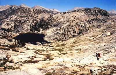
struck out into a lodgepole pine forest, eventually contouring our way to a water-filled
cirque known as Grouse Lake. We had planned to push further, but the lake's tranquil
beauty seduced us to stay here for the night. This wasn't a forced march, but an
exploration.
|
|
Sleeping
outside that night, Steve and I were mesmerized by a laser-like light show of flashing
meteors. One unique shooting star moved east to west in the otherwise blackened sky.
Instead of streaking in a straight line, it lazily undulated. Others meteors left brief
tracers of brilliant light. In the morning, light ice covered our sleeping bags and left
the water in Steve's water container frozen.
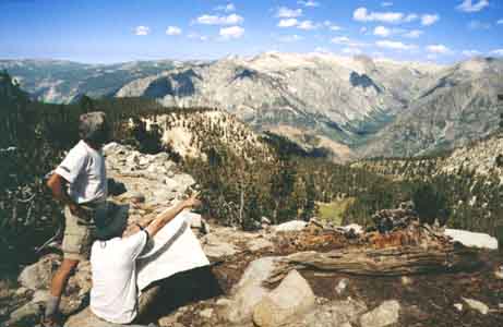
The next
morning we hoofed up 11,050-foot Grouse Lake Pass, where the reward included a 360-degree
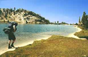
view of towering granite peaks. We dropped two miles down platforms of granite slabs to
the highest of four Granite Lakes. Set in a cupola and surrounded by spiring peaks and
weathered, twisted whitebark pines, the upper lake is one of the most idyllic I've seen. I
spent the afternoon swimming, washing clothes from a bucket of lake water and reading from
a grassy bench with my feet in the sand.
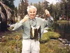
Ravenous Trout and Ragged Peaks "Wherever"
proved to be one of the several Horseshoe Lakes, where the attractions were lure-hungry
rainbow and hybrid trout. Steve took two casts and pulled in two keepers. My first came on
the third cast. We soon had enough for dinner. After our ritual "happy hour" I
fried them over my stove in remnants of oil culled from a can of neatly packed
caper-filled anchovies. Foods we never eat at home — canned sardines and smoked
oysters — were treats we devoured in camp. |
|
The day's
hike had featured an anxious scramble down a 300-foot step drop that, seen from the
bottom, looked like a dried-out waterfall. After traipsing alongside meadows, the route
joined a signed trail which we promptly lost. We found our way to State Lake, where we met
a wilderness ranger who recommended this lake with the ravenous trout.
The
following morning we angled off the trail to White Pass, where we climbed a ridge with
increasingly panoramic views of row-upon-row of spired granite peaks and river-gouged
canyons. We crossed Windy Ridge and weaved a steep descent to a beautiful pond, then
crossed a saddle, descended a steep gully, lunched by soothing pools, then stepped our way
back up Red Pass.
|
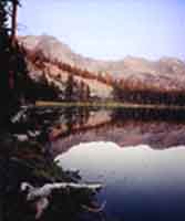
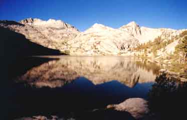
"The
country continues to be incredibly and dramatically beautiful in a very rugged, raw sense.
The canyons are huge gashes, the mountains sharp-sided slabs of violated, fractured
rock," reads the journal entry I scribbled that night from a perch by a
clear-beyond-belief lake that fills a granite basin at about 11,000 feet. To the north
were a series of peaks, as irregular as ragged teeth. The sunset revealed layers of
successive mountains that merged into a single mass in the morning light.
"This
is probably the most remote location I've spent time at," reads my journal.
"It's a day's walk to a trail, and then another long day's hike out in any direction
... bare, vacant, but full of another kind of life and energy. During the night we
listened to the sounds of wind, marmots, squirrels, birds and silence."
|
Happy Trails More
sights left us bewitched in the days that followed. Other fish were eaten fresh; others
cleaned, packed in ice and later grilled. Sunsets colored the skies in shimmering soft
lavender hues. We lounged at pastoral ponds and camped at an expansive lake specked with
granite islands. Breezes carried flavors of mint, manzanita and pine. Once, while waiting
for Tom and Steve, I sat motionless as a deer promenaded into a meadow, then padded
through the densely flowered field, nibbling the grass. |
The hike
back to Cedar Grove included several miles on a well-built trail, including sections where
crews laboriously created steps from enormous stones. But instead of gazing and pondering
as we'd done on the High Route, we more purposely covered the miles on the highway-like
trail. This route aimed through lower elevation, tree-bracketed forests.
We already
missed the high country's off-trail views. We thought back to Tom's exclamation,
"This is fun!," when we had stopped for a water break while traversing the High
Route. Fun it was. There's something exhilarating about relying on a map and compass. It's
a sense of being alert and alive, of not simply following a well-traveled trail.
Click
here for details to plan your own trip to the High Sierras.
Lee Juillerat
Articles and Photos